Thursday 23 October 2014

Year 8 Half Term Holiday work

Common Entrance:

Year CE candidates please look over the Global Location list ... You need to know the names of all of the physical features and major cities AND be able to draw them on a map: the map could be a map of the world, or a continent or even the British Isles. 
Blank maps and the list of Location Knowledge required for CE can be found on the left hand side of this page.

Scholars

As requested, here are two essay questions for you. Do at least one of them, please.

Question 1.
Read the extract from the Daily Telegraph from 10/04/2012:

This month marks the second anniversary of the eruption of Eyjafjallajökull that left millions stranded across Europe, and cost airlines an estimated €150 million a day for six days. But alarmingly, there are signs of high activity beneath the much larger, neighbouring Katla caldera in Iceland – a possible sign of an impending eruption. This should prompt extensive high-level contingency planning across Europe, as Katla has the potential to be much more damaging than Eyjafjallajökull.

a: i) What type of plate boundary is Iceland on? (1)
ii) Why are volcanoes often found on this type of plate margin? (3)
b: i) Approximately how much did the eruption cost the airlines? (1)
   ii) Why was the cost of the eruption so great? (2)
  iii) How might the eruption have affected ....
     1: local people (2)
     2: people outside Europe (3)
c: Why do people live near volcanoes? (4)
d: Why might the effects of this eruption have been different had it happened in a poorer country? (9)
Total 25 Marks
Question 2.
Look at the two photographs taken of Alvor in the Algarve, Portugal.
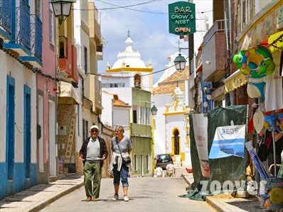
A typical street in Alvor

The Pestana Beach Club in Alvor


"Tourism is good for an area". Discuss. You should use evidence from these photographs and other examples that you have studied.  
 
25 marks


Saturday 18 October 2014

An undersea world of peaks, canyons and volcanoes

The search for the missing Air Malaysia flight MH370 which disappeared about 6 months ago has led to an ocean floor topographical (relief) map being made. This has been done so that the scientists can 'fly' a cable close to ocean floor in order to get a map with enough detail to be able spot the wreckage of the plane. They need to know what is down there before they start dragging expensive equipment through the ocean.


The little 'bumps' on this image are about the size of Ben Nevis! The big mountains are huge!

We know very little about the deep ocean floor. It is too remote and hostile for humans to visit it regularly, let alone survey it.

Interesting article in the Telegraph brought to my attention my father-in-law.  Read the article.

Wednesday 15 October 2014

Live Volcano and Earthquake Map

Just stumbled across this excellent resource.


It is a world map with live feeds of erupting volcanoes and recent earthquakes. Click on the volcano and it will give you more information and live webcam images (if they are available). 

To go to the web page: click here.

Thursday 9 October 2014

Scary Moving Ice

Thank you to Mr Price from Charterhouse for this clip ...


This follows on from the glacial retreat shown by the time lapse on Google Earth a few days ago ...

 
To readthe whole Google Earth article click here.

Tuesday 7 October 2014

Men, Maps and Minecraft

Although I am not an afficienado of Minecraft and am genuinely amazed at the hours and hours that children of various ages seemed to dedicate to creating their own blocky universes, I have to accept there is case to recommend it from a geographical viewpoint.

Take this world below ...
Zelda: Twighlight Princess map created in Minecraft by Kezsonaj 
  
It has been created in Minecraft and is a faithful recreation (or so I am told in the blurb that accompanies it) of the lands created in the game Zelda: Twilight Princess.  When you zoom in the landscape is created in fine detail such as this palace below.


Although it is clearly uberadictive and for some people who fear daylight, it has become a way of life, it is useful to help teach children how to visualise in 3D cartographic 2D information. It is a sort of virtual Lego.
 
A long time ago I extolled the virtues of games such as Doom and Wolfenstein, for once you ignored the gratuitous violence and spurious plot, playing them involved a sort of virtual orienteering: you had to find objects or locations on a map and then find them in the virtual reality of the game. Even better, if you could take your bulky PC around to your friends house you could connect your computers with a serial cable (the days before USB and indeed wireless connectivity) and spend many happy hours chasing each other around the mazes with a rocket launcher: such fun!

Level 1 of Doom: Remember to shoot the exploding barrels ...
 
These games, especially Doom, took this to the next level as 'creator' software was spawned that enable you to create your own mazes and hide objects, monsters and secret doors all over the place.
 
Minecraft is an illogical development from here but it shows that perhaps human nature is more interested with the creative than the destructive and violent. People all over the world are spending thousands of hours creating virtual environments that would have made Slartibartfast proud. 
 
Slartibartfast breaking the news to Arthur Dent in the Hitch-Hikers' Guide to the Galaxy that he designed Norway on the original Earth ... (Original BBC TV Series)
 
 
However harmless this passtime may seem, there is part of me that thinks that these people ought to not just look outside their window, but open their door and walk around and find out how extraordinary the real world is ...
 
Picture by Dave Morrow: Most Amazing Landscapes (go to his page and see more images)
 
... the advantage of the real world is that you can smell it and feel it.


Time Lapse Google Earth


Now that satellite imagary has been around for a while, we can start to track how th esurface of our planet has changed over time: since about 1984 to be exact.

This article in Time online shows timelapse video footage taken from Google Earth as well as a couple of examples which you can explore in Google Earth. They include urban development in Dubai, rainforest deforestation in the Amazon and rapidly retreating glaciers in Canada. 

Technology can be a wonderful thing ...

Click here to read whole article.